

Advancing smart agricultural technologies like IoT and big data, with a focus on developing a farm machinery management platform that enables tasks such as drone-based plant protection, rotary tillage, sowing, and harvesting.
This platform allows for real-time quality monitoring, task assignment, automated irrigation, and control of pump stations, including remote operations for opening/closing of pump stations, water level control, and fault alerts.
By connecting people and data intelligently, it achieves precise agricultural management.
-
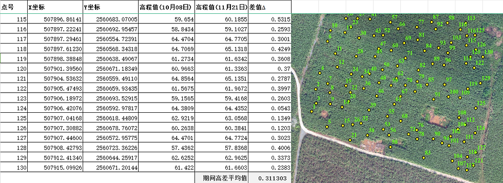
Utilizing remote sensing drones to generate high-resolution field maps, these maps serve as a base for clearly outlining field boundaries. Data related to agricultural tasks, crops, machinery, IoT, etc., are managed based on spatial coordinates and time dimensions, enabling automatic data association with specific field plots.
-
Through GIS visualisation, the entire process from planting to harvest of each crop season is presented, allowing managers to have a comprehensive overview of the farm's production and operational status at any time.
-
Managing data related to agricultural tasks, crops, machinery, IoT, etc., based on spatial coordinates and time dimensions, automatically associating data with specific field plots to polish the data input processes.
-
Establishing a precise high-definition map.
-
Setting up Beidou precise temporal and spatial service infrastructure.
-
Implementing a unique code management system for each area.
-
Maintaining production management zone planting records.
-
Monitoring soil characteristics.
-
Managing water resources.
-
Monitoring salinity and alkalinity conditions.
-
Assessing soil fertility.
-
Tracking pest and disease situations.
-
Managing weed infestations, and more.
2. Water Resource Ledger Management Subsystem

A farm machinery management platform that advances smart agricultural technologies like IoT, big data, standardized planting for intelligent water management.
This platform streamlines tasks such as drone-based plant protection, rotary tillage, sowing, and harvesting, providing real-time quality monitoring, task delegation, operational tracking, automated irrigation, and pump station control.
It enables remote pump station operations, water level supervision, and fault alerts. By integrating people and data seamlessly, it ensures precise agricultural management.
-
Digital, intelligent and and traceable the water management actions in experimental fields for easier record-keeping and issue tracking.
-
Ensuring timely and accurate implementation of water management measures without significant additional monitoring costs.
-
Using automated equipment to replace repetitive, labour intensive agricultural tasks, reducing associate risks due to manual operations.
-
Enabling proactive alerts to prompt correction of anomalies, with timely involvement of technical personnel in case of equipment failures to prevent losses.
-
Providing clear statistical analysis for multi-dimensional assessment of water management progress and anomalies, identifying the root cause for every issue.
-
Achieving information transparency through intelligent recording of water management processes, reducing management costs and improving efficiency.
-
-
Features:
-
Irrigation calendar function for land plots, allowing customization of irrigation templates and setting conditions for facility and equipment actions.
-
Alert system to notify managers of abnormal states in water valves to ensure timely awareness of their operational status.
-
Remote control of water valve opening and closing.
-
Real-time access to information of current field drainage and water level.


4. Meteorological Resource Ledger Monitoring Subsystem
Enabling accurate meteorological applications that involve viewing weather forecasts for upcoming days, accumulated temperature, and rainfall.
The system monitors data from small-scale agricultural meteorological stations, soil moisture using on-farm meters, issues moisture alerts, tracks insect occurrences with monitoring lamps, conducts real-time farm surveillance via high-definition cameras, and gathers crop growth data.
It seamlessly integrates with IoT devices meeting interface specifications, incorporating data from various sources like weather stations, high-definition images, audio recordings, agricultural recorders documenting crop growth, soil sensors, and spore counters for disease and pest detection, among others.
-
Standard IWS station on 7 weather elements, including light intensity, rainfall, air pressure, wind direction, wind speed, temperature, humidity.
-
SM soil sensors (supporting humidity, temperature, and conductivity data collection with a depth of up to 50cm and 5 underground contact points).
-
Solar panels for serial power supply, ready for immediate use with pole mounting.
-
Self-powered + 4G network, built-in data card with recharge services.
-
Monitoring system of 4 conditions...
Soil Moisture Monitoring Service
Weather forecasting service


3. Biological Accumulation Resource Ledger Management Subsystem
Based on the planting plan, the system develops agricultural plans for the farm, issues agricultural tasks, customizes farm staff roles, and displays pending agricultural tasks within authorized scopes. It records agricultural activities and provides feedback on task execution results.
Presented in calendar formatting for daily agricultural schedules in calendar format, and in a dashboard formatting for dissemination of agricultural statistical analysis data to farm staff and management personnel.

Management of Growth Stage Progress
Providing an overview of the distribution of various growth stage field operations across the entire farm, tracking the growth status of each field during different periods, and visually presenting the progress of each field's growth stage process via a timeline.
Agricultural Progress Management
Providing a comprehensive overview of the distribution of agricultural operations across all fields in the entire farm, tracking the progress of each field's agricultural tasks, and visually presenting the progress of agricultural activities in each field via a timeline.


Crop Variety Management
Offering a holistic view of the distribution of planted varieties across the entire farm, and calculating the actual planting area for each variety.
Utilizing drone monitoring to collect crop growth information, monitoring the growth cycle of crops based on soil and historical climate data, and providing a basis for irrigation, fertilization, plant protection, harvesting, and other agricultural activities.
Providing analysis on terrain, seedling emergence rate, meteorology, soil moisture, soil fertility, weed, crop growth, yield, etc.
-
Yield estimation
-
Production prescription map operations
-
Terrain analysis
-
Tillering count
Dynamic Weed Monitoring
Analyzing low-altitude remote sensing data through aerial patrols to automatically identify inter-row weeds, tracking the dynamic growth of weeds in each field promptly, and capturing the optimal weeding period.


Crop Growth Analysis
Quantitative analysis of crop growth using image data to promptly identify issues.
Basic Seedling Analysis
Automatically collecting and identifying basic seedlings, adjusting cultivation measures based on deviations from target values, laying the foundation for high yield, quality, and stable production.
8. Intelligent Agricultural Machinery Operation Supervision Subsystem
Displays data on operations of agricultural machinery and drones monitoring, including machinery data, scheduling information, operational information, operating conditions, statistical information, etc. To facilitate digital management over the network and digitization of agricultural machinery and IoT devices.
-
Creating agricultural machinery tasks that specify operation areas, equipment, and automatically plan routes. Real-time monitoring of machinery position, operational status, conditions, quality, and faults. This allows for effective platform control functions including enquiry of scheduling data, re-evaluation of operations, quality analysis by plot, and check on operational logs and fault records. Ultimately, providing management with operational supervision of farm machinery and equipment.
-
Enquiry of the status of associated with agricultural machinery equipment, such as viewing online/offline status, operation status, operation area, operation trajectory, etc., allowing the tracing of all field operations.
-
Integrating agricultural machinery equipment used for crop planting and harvesting into the system, supervising machinery and drones, setting speed limits and receiving alerts for exceeding limits, viewing trajectories, operation areas, and replaying operation trajectories.
-
Automatically recording all field operations for traceability.
-
Issuing proactive alerts for timely corrections in case of anomalies.
-
Conducting statistical analysis to analyze operation progress and anomalies from multiple dimensions.
-
Generating daily operation reports sent to mobile devices regularly.


7. Comprehensive Production Management Subsystem
-
Provided through both the web and application, the System extracts and consolidates data on crop growth, aerial inspections, ground patrols, farm machinery, drones, etc. It allows users to apply ground patrol management, agricultural management, crop data management, and operation data management. Further, enabling specific agricultural management information recording and data analysis by plot.
-
Supports export and of data for traceability management.
-
Comprehensive agricultural management
-
Publication of traceable data
-
Full traceability management system.
-
Establishing an archive of agricultural technology knowledge and decision models to facilitate the transfer of agricultural knowledge and reduce the barriers to agricultural learning.


9. Production Management Subsystem

5. Agricultural Waste Resource Ledger Management Subsystem
The efficient management of agricultural inputs involves recording inventory and processing procedures such as storage, issuance, damage reporting, etc. This includes conducting inventory checks, setting expiration date reminders, and maintaining detailed records of product information.
By accurately managing inventory and consumption data, real-time access to precise inventory levels is enabled, supporting timely and informed decision-making for waste management.
Accurately managing the expiration dates and quantities of pesticides to prevent unnecessary losses of production materials due to expiration.
Cross-checking inventory, inflow/outflow data with consumption data during the production process, utilizing operational data analysis tools to help strictly control the consumption of production materials.


10. Intelligent Decision Support Subsystem
-
Using artificial intelligence (AI) combined with big data technologies, expert planting experiences are transformed into precise identification models, providing timely and comprehensive scientific guidance on crop growth, including emergence rate, planting density, leaf age diagnosis, agricultural growth status, etc.
-
The AI identification model becomes more accurate as the learning samples increases.
-
Employing artificial intelligence (AI) and big data technologies to perform calculations, generate various prescription diagrams, and provide decision support data throughout the entire planting and harvesting process.
-
Users can also choose specific plots, access plot details, and based on their selections, obtain expert-assisted planting schemes. These schemes consist of five components: planting strategy (throughout the entire growth period), basic seedling analysis, plot information, growth records, etc. The planting strategy showcases the entire growth period, including seeding operations at different stages, water and fertilizer requirements, disease and pest control, yield predictions, etc.; it also offers initial unit price settings for easy bulk processing across multiple plots...

6. Low-altitude Remote Sensing Data Analysis Subsystem
The low-altitude remote sensing subsystem is primarily designed for drone field inspections and supports the design of field inspection parameters. Timely feedback on abnormal points during inspections are facilitated by alert notifications, significantly enhancing the efficiency of field inspections.
Through AI and image analysis technology, field abnormalities are promptly identified and recognized, effectively guiding management personnel in addressing field anomalies.
-
The main function of aerial inspections is to use remote sensing drones to replace manual field inspections, such as examining water levels, disease and pest situations, and field conditions using remote sensing drones.
-
Establishing precise high-definition mapping
-
Setting up Beidou precise spatiotemporal service infrastructure
-
Comprehensive and accurate data collection
-
Data evaluation and automatic classification
-
Checking water levels
-
Checking of growth conditions
-
Checking of seedlings
-
Checking of leaf-ages
-
Disease and pest situations
-
Weed situations...
Figure 1: Aerial inspection to observe seedling conditions, enabling remote guidance
Figure 2: Drone patrol for field inspections
Figure 3: Drone patrol for field inspections
Figure 4: Drone patrol for field inspections: Identifying weed infestations


11. Digital Crop Planting Model


List of Modules for the Data Governance Agricultural Cloud Platform
Platform | Item | Application | Function Summary |
Data Governance Agricultural Cloud Platform | Base Platforms | Land plot management | Using a high-definition map as the base map to overview all the land parcel boundaries, planting and growth information, and equipment distribution across the entire farm. Support grouping land parcels by production zones, assigning responsible persons for production zones, and generating statistical analysis reports by production zones. |
Infrastructure Management | Record boundaries and location information of basic facilities such as sun-drying areas, pump rooms, warehouses, and water inlets and outlets via the farm's spatiotemporal database for a holistic view of the distribution of basic facilities. | ||
Planting Model (Rice) | Digital crop models, AI self-learning | ||
Seasonal Planting Management | Support management of all data on the entire farm by planting season, accumulating historical data, and enabling comparative analysis. | ||
Aerial Field Patrol | Low-altitude remote sensing unmanned aerial vehicles support various field patrol modes: surveying mode, 3D surveying mode, and patrol mode. Remote sensing data are gathered to generate high-definition 2D maps with accuracy down to the centimeter, 3D terrain data, and crop group growth status data (including visible light and multispectral data). | ||
Mobile App Field Patrol | Collect field patrol photos and location information using a mobile app or mobile platforms such as WeChat Work, WeChat mini-programs, and DingTalk. | ||
Multi-dimensional Data Analysis | Based on aggregated growth data, environmental data, agricultural execution records, etc. to perform multi-dimensional data analysis, while support comparative analysis of data from different seasons. | ||
Phenology Management | Through a holistic view, visually observe the distribution area and size of each phenological period and view the progress of each phenological period via a timeline. This provides a basis for agronomic decision-making and overall agricultural measures. | ||
Production Planning and Process Management | Based on leaf age progress, set phenological periods, define production elements for each stage based on phenological periods, essentially setting standard recording points for the informatization of the production process. Using defined production stage elements, conveniently enter agricultural execution records (including inputs, time, land parcels, weather data, and automatically related drone and farm machinery operation records) using mobile apps, WeChat Work, DingTalk, and other platforms. | ||
Variety Management | Provide an overall view of the distribution of planted varieties across the entire farm, calculate the actual planting area for each variety, and visually present the complete sowing/planting process for each variety through a timeline. | ||
Agricultural Inputs Management | Offer an overview of the distribution of agricultural input products across the entire farm, calculate the actual amount of each agricultural input product, and visually display the progress of input for each agricultural input product through a timeline. | ||
Smart Applications | Topographic Analysis | By establishing elevation data for land parcels, it is possible to assess the amount of leveling work required before field operations, plan the leveling operation paths, and evaluate the effectiveness of the leveling work after completion. Additionally, based on the topographic data, design rice field patterns and measure the depth of wheat field ditches. | |
Seedling Analysis | Basic seedlings for rice and wheat are fundamental data for precision agriculture. Obtaining the optimal density of spikelets based on the target yield from suitable basic seedlings is a fundamental approach in precision agriculture. By automatically collecting and identifying basic seedlings and adjusting cultivation and control measures based on deviations from the target value, a foundation can be laid for high yields, quality, and stability. | ||
Growth Comparative Analysis | Using agricultural recording devices to collect crop growth photos at specific points and comparing the growth at different time points within the system. | ||
Crop Growth Analysis | Utilizing multispectral data to quantify crop growth through NDVI, LAI, chlorophyll index, etc., and promptly identify issues. | ||
Intelligent Execution | Setting trigger conditions associated with data sources to execute specified operations, for example: issuing a frost warning and halting pesticide application when the temperature drops below 0 degrees Celsius. | ||
Operational Supervision | Automatic Recording: All processes of intelligent agricultural machinery operations in the fields and the operation tracks of traditional farm machinery are traceable. Active Alerts: Timely alerts in case of abnormal situations. Statistical Analysis: Multidimensional analysis of operation progress and anomalies. Active Reporting: Daily generation of operation reports sent to mobile phones for timely updates on operational status. |
Platform | Item | Application | Function Summary |
Data Governance Agricultural Cloud Platform | Advanced Intelligent Applications | Seedling Uniformity Analysis | Through seedling uniformity analysis, regions with missed planting or seeding gaps are identified. Using algorithms, the system accurately calculates the area and distribution of these gaps, promptly detecting missed planting areas and allowing for manual replanting. It also quantitatively assesses the quality of seeding/transplanting operations. |
Weed Growth Monitoring | By analyzing low-altitude remote sensing data from aerial surveys, the system automatically identifies weeds between crop rows and monitors weed growth in each field, capturing the optimal period for weeding. | ||
Lodging Monitoring and Analysis | Based on high-definition images collected from the farmland, the system automatically calculates the area of lodging (flattened crops) for each field and marks the boundaries of the affected areas. | ||
Spike Count Analysis | Using multispectral data, the system automatically calculates the number of rice and wheat spikes. By analyzing this yield factor, it enables a cross-comparison of results between different fields, providing a precise, quantitative analysis of variations among them. | ||
Rice and Wheat Harvest Progress Analysis | Based on spectral data, the system automatically identifies harvested fields and even calculates the harvested area of each field, thereby estimating the overall harvest progress. This provides a basis for coordinating agricultural tasks in accordance with crop rotation schedules. | ||
Yield Estimation | Combining data from point sampling, spike count analysis, and crop growth data, the system comprehensively estimates the yield of each field. | ||
Supporting applications | Patrolling Fields from the Air | Low-altitude remote sensing UAV | Utilizing a quadcopter for aerial patrolling, remotely controller, equipped with four batteries and one charger with third-party liability insurance, for optimal planning. |
Mapping camera | Easily conduct high-precision mapping down to the centimetre, provide cloud-based stitching solutions, and generate high-definition maps at a scale of 1:500. After the intelligent agriculture brain automatically identifies field boundaries/crop locations, it can directly import into plant protection drones for fully autonomous plant protection operations. | ||
Multispectral camera | Capable of capturing high-definition images of crops in four bands and high-definition RGB visible light images, you can directly view pixel-aligned index maps on-site, immediately assisting agricultural production decisions. With the aid of AI-generated field operation prescription maps, it can directly guide agricultural plant protection drones for prescription map plant protection operations. | ||
Sensors | Small-scale Field Weather Station | Integrated weather station, rust-free and dust-free, accurately measuring seven meteorological elements including air pressure, temperature, humidity, light intensity, rainfall, wind speed, and wind direction. | |
Soil Sensor | The sensing part with an IP68 protection level is buried deep underground to 50cm, resistant to dust and water immersion and corrosion, free from interference, accurately measuring soil temperature, moisture content, and conductivity at 5 different levels, suitable for various soil types. | ||
Temperature and Humidity Meter | Utilizing highly sensitive temperature and humidity sensors, precisely detecting ±1℃ temperature changes and 5% relative humidity changes, measuring every 5 minutes for more accurate data. | ||
Smart Equipment | Automatic Leveling Device | Using intelligent agricultural machinery with mounting of the XAG intelligent leveling instrument, achieving up to ±5cm leveling accuracy. The leveling device can receive RTK signals in real-time, utilizing hydraulic expansion and automatic calibration technology to achieve standardized, stable, and uniform leveling operations. | |
Unmanned Operation Platform | The unmanned operation platform features a streamlined modular design, a stable carrying platform, powerful expansion capabilities, and diverse working modes. It can be equipped with air flow sprayers, agricultural logistics systems, and other smart agricultural devices to provide precise plant protection, intelligent field monitoring, agricultural material transportation, and other agricultural services. While meeting various needs, it achieves a 'triple win' scenario of ecological, economic, and social benefits through improved operational effectiveness and higher efficiency, thereby illustrating the rich connotation of smart agriculture. | ||
Communication Interface | Data Collection | ||
Services | System Implementation | Delivery | Role setting, training, delivery operation, system acceptance |
System Maintenance | System Maintenance | Drone supervision data verification, high-definition data automatic stitching services, spatiotemporal data storage, cloud server leasing, system upgrades, data backup, 7x12 technical support |